The Discovery Channel has a TV show "
Storm Chasers" that describes the real-life adventures of meteorologists chasing tornadoes. They drive in heavily armored vehicles with weather sensors on them and try to get in the path of storms. One team is making an IMAX/3D film, others are making videos and collecting meteorological data.
The show has drama, danger, frustration and excitement. Oftentimes the forecasts are a bust, the teams get lost, the storms fall apart, or just nothing seems to work right. Occasionally, though, they get to experience the full fury of nature and live to tell about it. But why should weathermen have all the fun risking their lives in the name of science? Here, written in the style of a Storm Chasers episode, is the story of our adventures in spotting streamgages on our way to an interview for my book.
TOM: "2011 was a wild year for central New England. In June
a massive tornado literally sucked the Connecticut River into the air. Then Hurricane Irene in August caused flooding all up and down the East Coast, destroying dozens of houses here. There was a killer cold blast in November; unprecedented snows buried everything and knocked out power to more than three million people. When that snow melted, the streams went buck wild."
TOM: "But disasters like these can be prevented. If hydrologists have the right data, they can warn people to get out of harm's way. Hopefully some of the information that's being collected today will result in advances in the way that forecasters make predictions. At the end of the day, it could save lives."
ANNOUNCER: Today we're joining Team S.I.V. in their
Stream
Intercept
Vehicle. Kitty will be piloting the chase vehicle, guided by hydrologist Tom Pagano. These extreme flood chasers will be stalking streamgages in the central Connecticut region, north of New Haven.
 |
| Our Big Red Shoe: The S.I.V. Streamgage chasing vehicle is gassed up and ready to go. |
KITTY: "I'm a little nervous about today. A couple weeks ago we were
stream chasing in the open plains of Colorado. There, you can see the rivers in the valleys from miles away. Here in the closed in woodsy areas of New England- you have nearly no warning. You'll be barreling down the road and cross a bridge and all of a sudden there's some babbling brook and it's too late to stop. You could slam on the brakes but it might cause a pile-up. The last time I did that Tom got coffee all over himself. Stream chasing today could be very
very dangerous."
 |
| We've got our Dunkin' Donuts. Now let's roll! |
TOM: "The S.I.V. is outfitted with the latest in stream monitoring technology. We have
Google Earth hooked up to the Internet through our mobile phone. We downloaded the
metadata layers from the USGS that show us where all their realtime measuring sites are [click the link to get your own copy.
Here's also non-realtime sites]. They are color coded by how high the streamflows are
this very moment. You can click on the sites and download the current water levels. We're going to see if we can use this information to locate streamgages and drive right up to them. We're going to see how close we can get without hurting ourselves."
 |
| Tom's streamgage monitoring workstation in the S.I.V.'s cockpit. |
KITTY: "Let's go where ever you think we have the best chance for deployment..."
 |
| Head for the blue dots for the intercept. |
TOM: "I'm not sure that we're going to see any flooding today but this area of dark blue dots is going to be our best shot at finding some high water. The darker the dots, the more extreme conditions we're expecting to encounter.
KITTY: "We never know what will happen though. In this job, the day could have anything in store for us. It's all a combination of information, technology, instinct and luck.... So where are we headed today?"
 |
| Target: Station 01196500 Quinnipiac River at Wallingford, CT |
TOM: "First stop is Wallingford Connecticut. This is a real important and historic site. It was installed in 1930 and has barely missed a day of measurements in 80 years. Since it's been around for so long and the watershed above it hasn't changed much, it is part of an elite set of stations used widely for scientific research called the
Hydro-Climatic Data Network. This site is also upstream of New Haven, a city of about 850 thousand people... Ok, to get there we need to get off Highway 91 and onto some of these surface streets. Go left here..."
KITTY: "I don't think this is right." [Drives straight at the traffic light]
TOM: "Kitty, go left! Go left! Gah... We're totally lost, this is a
complete disaster! This is
not good."
ANNOUNCER: Frustrated, team S.I.V.'s morale is dropping as they are forced to make a U-Turn in the warehouse district. Then suddenly, Wallace Dam comes into view.
 |
| Coffer-dam (left) at Wallace Dam. |
KITTY: "New England is full of small old dams. This eight foot dam is the last barrier to fish passage on the Quinnipiac River.
A fishway is being built so the fish can swim around the dam. These white bags on the left are called a "coffer dam" and they hold back the river flow while they do the construction to build the fish passage."
[The team continues to drive, checking the GPS]
TOM: "There's gotta be a streamgage around here somewhere. According to the map, this gage could be anywhere around us... We should be right on top of it!"
KITTY: "There! Across the highway! In the woods!"
TOM: "We have streamgage, I repeat, we have streamgage. Get ready to intercept."
 |
| Streamgage (white building) in sight. |
 |
| We had to race along an embankment and across four lanes of highway traffic. The debris of litter from passing cars was flying everywhere. It was a very dangerous situation. |
 |
| Success! |
 |
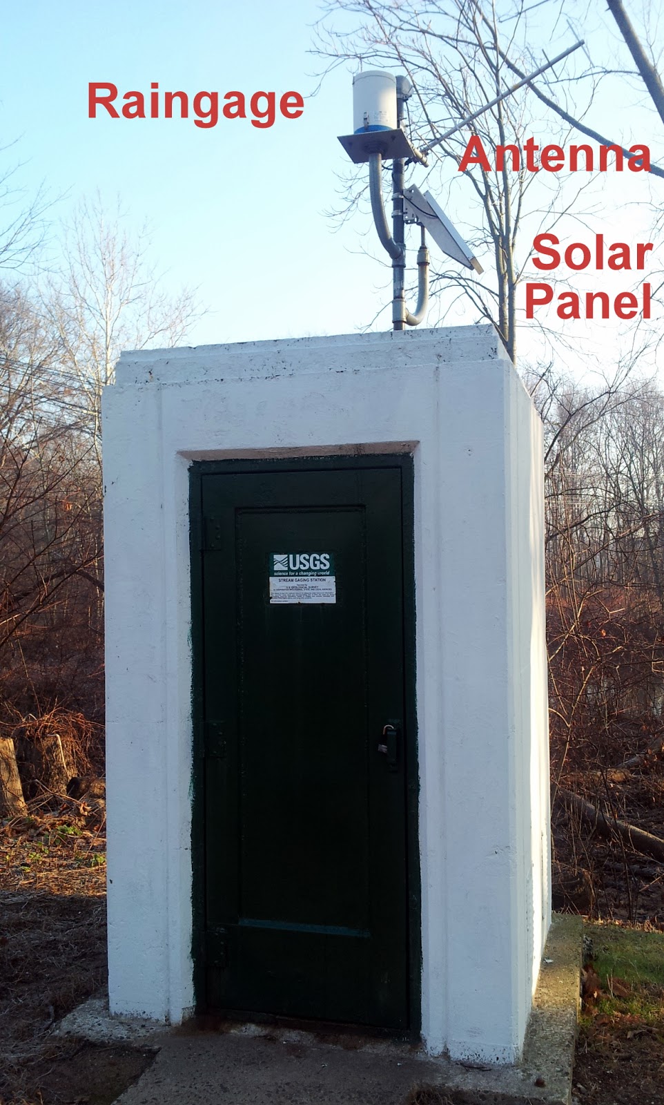
| The instrument shed of the streamgage. For being a concrete closet, it still has a bit of a 1930s art-deco feel to it. |
TOM: "This site has sensors that measure the height of the river and send the information to that white building. On top of the building, it is also equipped with a raingage. The solar panel is to power the site and the antenna is to transmit the data back to the
USGS. The USGS then makes that available to anyone, including river forecasters and emergency managers. All the data for all of the country is available, and is free of charge."
 |
| The automated measurements are verified against a "staff gage", a giant ruler that measures the river height. |
 |
| Wisps of fog come off the river surface. |
KITTY: "The river is looking pretty tame right now, but I heard recently it has been acting up. Let's see if we can get some historic data."
ANNOUNCER: Connecting their laptop to their mobile phone, the Streamchasers can easily download any of the USGS data they want. Within a minute, they are able to see a full history of the station...
TOM: "We're getting data like crazy right now. This site is still measuring new data as we speak..."
KITTY: "Check out that peak in March!!! It was over the 10-year recurrence interval! The river must have been violent, very violent!"
TOM: "And we just missed it by ten months..." [Beating his fists in frustration]
KITTY: "The 2011 Season was incredible; this area saw close to the highest water it has ever seen. Along the drive up we saw some storm and flood damage. People's lives and livelihoods were affected."
TOM: "But we're a long way from fully understanding how these streams behave. We need to get this data into the hands of forecasters and researchers. Communities need this information to make better decisions. We need to understand how this planet works and what's the best way for us to live on it."
KITTY: "I will say that 2012 is shaping up to be the strangest year ever. But in this business it always seems like next year is the strangest year ever. That's what I love about forecasting and streamchasing. You never know what's going to be around that next corner..."


Glad to hear you are making the most of your time in CT!
ReplyDeleteWe had 2.5" of ppt today in Sellwood. Snow level rising...water is flowing - downhill.
Sheila,
ReplyDeleteStay dry! When I looked at the National Weather Service's warning page at http://www.wrh.noaa.gov/, it was lit up like a christmas tree with warnings of severe weather. Reno had red flags next to heavy winter storm warnings in Tahoe.