Friday, October 7, 2011

Manila hydrologists in the heat of battle (part 1)

Last week the 3rd costliest Typhoon in Filipino history struck and another was about to track over the same area of the Philippines. I stopped in at the national weather/flood headquarters in Manila to see how things were going and got a chance to see operational hydrologists at work.  

Of course, the first typhoon (Pedring, known internationally as Nesat) was all over the news. Water invaded parts of Metro Manila including the US embassy... 

US Embassy under water (Source)
Considering that Manila is so security conscious that even the local pharmacies have shotgun-wielding guards, just imagine the frenzy this must have caused. The TV had full-time live coverage including, among other things, waves crashing over the top of palm trees. 


This was on the two year anniversary of another legendary typhoon in 2009 (Ondoy aka Ketsana) that wrecked Manila. With 80% of the city under water, it was described as a "once-in-a-lifetime" flood, and there was some criticism that there wasn't enough warning). A couple days after the 2009 storm, another typhoon struck (Pepeng aka Parma). Despite Ondoy being seared into local memory, it was this second storm that holds the record for costliest typhoon in Filipino history. Manila was largely spared but the rest of the north island was totally creamed. 

The Philippine Atmospheric, Geophysical and Astronomical Services Administration (PAGASA) makes weather, climate and river forecasts and follows current conditions. There are field offices that make forecasts in some places, but it's all funneled through the Manila (Quezon City) headquarters.


When I got to PAGASA's office, a large tree had been uprooted in their front yard. The forecasters would have had to pass by it on their way in and out of work.


The lobby of the headquarters was stuffed with lights, cameras, soundboards and rivers of thick black cables. Even though Pedring had come and gone, the media was making its own forecast by leaving the gear in place in case the next typhoon (Quiel, aka Nalgae) was going to be big news. The anchor men and women swept in and out of the scene whenever there were press conferences. The media technicians stayed around-the-clock, often nodding off in the plastic lawn chairs in the oppressive heat.

Or watching youtube videos
The contrast between awkward silent geeks attending on impossibly beautiful hosts felt like I was channeling a teenage dream.  


So, to recap, 2009, consecutive typhoons, both causing incredible damage. The first hit Manila and the second passed to the north. Then this year, consecutive typhoons, the first hitting Manila and the second was forecast to... to do what?

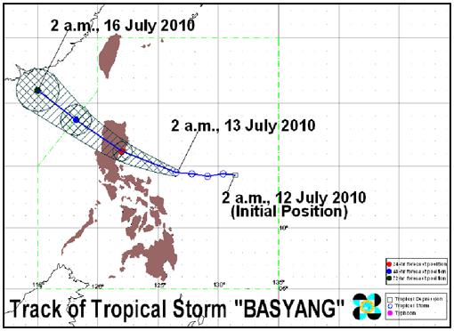
Before you say "pass to the north" consider that in 2010, Typhoon Basyang (Conson) was forecast to do just that and instead rolled through Manila by surprise. I plotted the forecast one day before landfall in 2010 compared to the actual storm track. There was a forecast range of possibilities, but the observed was outside even that.

What happened last year
The president gave PAGASA's chief a public tongue-lashing, then demoted him and eventually he resigned.

Tense enough yet?

Saturday, October 1, 2011

Waiting for Quiel in Manila

As the typhoon passed through Manila we decided to drive around and see high water. Note to self, the radio network for taxi cabs is a great way of asking which places are having urban flooding. Marikina City probably had the biggest waters in the city because it is just above the floodway that diverts high flows to the inland lake. A mall's basement went underwater as well as a few parks. People were wading through water along a bridge. 


Last night, a second typhoon was expected to make landfall in the same place as the first. Here was the image at 5 am, from PAGASA (the national weather service). There's always an excitable awe when the first images of a well-defined storm eye arrive at the forecasters.  


 I was able to get down to the flood warning center and camped out until midnight, going between the flood forecasting area and the media center in the lobby. It's exciting for me to be embedded with forecasters during an actual flood event and hope to tell more later (the event is still going on).  

The atmosphere at the office last night reminded me of waiting at a hospital for a patient to come back from surgery. Lots of people waiting (such as camera crews for the media, or other assistants) with a sense of tense boredom, pacing, staring at the ceiling, clicking away on their mobiles. I wondered if it was worth it to bug the "nurses" for new information or if we just needed to wait for the next release. Like an emergency room, there is no window in to see the patient, only the occasional reporting of vital signs. Even these required some interpretation ("the hemoglobin levels are 8.0"... "7 gates of the dam are open"... is this good/bad/unusual?)   

In a sudden burst, a "doctor" would charge through with others in tow and the room would have to be cleared for an important meeting. With all the authority of a doctor, the undersecretary of the weather service (Yumul) thundered at a press briefing when asked "What's the worst case scenario?" -- “(The) worst case scenario is people will die if people will not heed (the warnings of) local authorities.” 

Next press briefing is in 10 minutes, for now we're still in limbo. 

Monday, September 26, 2011

Typhoon Nesat in Manila

It's not every day that you wake up and the weather forecast is for "broken trees".


We arrived in Manila, Philippines last night to horizontal blowing rain. On the ride to the hotel, some of the streets were flooded. A Typhoon is bearing down on the northern Philippines. The headline of the newspaper was "100,000 People Evacuated" as it made landfall this morning. This is happening on the two year anniversary of another Typhoon that killed more than 500 people and put 80% of Manila under water. It must feel strange to be unveiling memorial statues in stormy weather.
Satellite image from 20 minutes ago (9 am local time) from PAGASA
Here, the winds aren't terribly strong (the trees are bending a bit less than in the icon above), but the rain continued all last night. Against the background of the skyscrapers, the white bands of rain look like a sheer curtain blowing in an open window. The lights have been flickering on and off.

The sense of anticipation is palpable. School was cancelled and government workers stayed home today. I've been hitting refresh on the government's forecast website (PAGASA) every couple minutes (the last update was due at 9 am... another version). Their facebook and twitter feeds have been fairly active. There agency also has some good background information on how flood forecasts are prepared.

Of course, it'll take some time before the rain causes the rivers to rise. How high will the rivers get? It seems we'll find out soon enough...


Saturday, September 24, 2011

Hydrologic oddities: The foul creek from the Black Cave (Gomantong Caves, Malaysia)

Imagine that you are a psychologist designing an immersion exercise for someone with a set of phobias. Maybe the patient is afraid of nasty things, dark spaces, bugs, bats, and so on. It needs to be a dank, foul place, where the walls are alive; creepy-crawlies can drop off the ceiling anytime... Let’s run a small creek through it, just for good measure. 


Welcome to the Gomantong Caves in northeast Borneo! 

The view of cave entrance, looking out

When you hear about "Bird's nest soup", this is where the nests come from. Birds (swiftlets) make nests out of spit on the roof and the sides of the cave. People climb hours, 90 meters high with ropes and bamboo ladders (Health and Safety would seriously disapprove). This is the “Black Cave” (Simud Hitam) named because its nests are not as clean as the more valuable nests from the harder to access but larger "White Cave" (Simud Putih). 


Honestly, I have to wonder who was the first person to climb to the top of a cave to harvest a spit-nest and put it in soup. What are all the other things they experimented with along the way but gave up on? It's a bit like Fugu ovaries... They're the most poisonous part of a fish that can kill you on eating it. However, someone figured out that you can ferment the ovaries for 3 years and then there is a chance you might not die. 


Really, who is the unfortunate person who waited only 1 year to figure out that was not long enough? Worse yet, who were his friends who decided to wait longer and give it another go?  
On the way to the cave there is the typical wild-monkey-in-a-tree (Presbytis rubicunda)
So, in the cave are also bats... literally millions of bats. The birds and their bats do their business and poop on the floor. Untold centuries of poop forms the spongy bed of the creek that snakes its way through the cave. The smell is like a punch in the nose.

I tell you, it's really hard to photograph in a cave. Note, bat poo (foreground, background).
Excrement is full of nutrients and so you would imagine someone would be taking advantage of this incredible biological opportunity. Shine a light on the wall or the floor and you'll see...


... wriggling centipedes and an unfathomable mass of cockroaches. The boardwalk is steep and slippery so be sure to hold on to the handrail...

The handrail. Seriously. Grab on and potentially touch a roach or risk falling into a catastrophic failure. 
To give you a sense of how rank it is, the cave's creek (right) fouls the normal river (left) as they join.


The Gomantong Caves happen because limestone is easily dissolved by the water flowing through it. When a landscape has much limestone, it is called Karst. It's why some streams disappear in a hole only to pop out of a cave somewhere else.

Imagine how the center of a log rots out before the bark, leaving it with random little holes, tunnels, and other hollows. The cross section of, say, a live pine tree is pretty simple and easy to describe, but who knows what it looks like inside a rotten log. Similarly, "holey" limestone is one of the most difficult landscapes to model in hydrology. On our search for "hydrologic monsters", we'll likely spend a lot of time near Karst.

By the way, the birds nests are so valuable that the cave is heavily guarded by the government. In the back of the cave there is a place for the guards to sleep. It's a terrible job, poisonous snakes and centipedes have been known to bite them and cockroaches eat at their skin when they sleep. At least there's a cave cat (the glowing eyes in the center right of the below picture) that keeps them company (while feasting on birds). 

I think this counts as a zero-star accommodations

Thursday, September 22, 2011

In the Shadow of the East Floodway

Closer in to Jakarta, the rivers take on an ominous color. The water is black, bubbling, filled with trash and liquid horrors, the smell is overpowering. Although the main channel is usually black, the occasional backwater canal will bloom with algae. One lake we saw had floating islands of cornflower-blue colored scum.

There were places where the river went beyond black and developed white patches. Quite literally this was "white discharge", the same phrase you would use for a wound that has taken a turn for the worse and is weeping pus.


I imagine that this is what the Rivers of Hell look like. Know that my father was a Roman Catholic minister and I thought of Hell much more than any 10-year old probably should have. So, Hell is not a term I toss around lightly. If you are not religious, imagine The Bog of Infernal Stench or something from Lord of the Rings. 


As a hydrologist (but not a water quality specialist I will admit), what is all the more disturbing is that poisoned water does not necessarily look or smell bad. This mostly looks bad because of the human waste, but who knows what the industrial rivers look like. 


We visited the head of the East Flood Canal, a recently completed $500 million works project to prevent Jakarta from flooding. The canal is a protective quarter-ring around the southeast of the city, intercepting rivers and diverting floods out to to the ocean. 


As we stepped out of the van on the side of the canal opposite the College of Transportation (STMT Trisakti) someone asked "Is that a person down there?" 


Indeed, one of the trash pickers was swimming in the river, putting trash on a raft. For the interested, here is a good interview with one of these "river janitors".


The white foaming is likely from household detergents. Below is a closer picture of the cleanup along the trash racks. The rake is the cage of a fan, tied to a bamboo pole. 

For reference, "river janitors" like these make about $650 per year, compared to about $2000 per year for river gate operators (Indonesian median income is about $3000).

A small village of tin sheds now sits where the canal meets the old river flowing down its natural channel. Here is a house put up against a gate under construction. Eventually this will have to go away when the gate is completed. 


When we arrived, a group of boys were splashing and playing in the river within sight of a latrine.


The arrival of visitors caused a stir and all the kids came out to meet us and play games. All the girls had pink somewhere in their outfits...


And the boys liked climbing in trees and playing with toy guns. 


We found an old woman that had lived in the village for 30 years. She said the last time they were flooded was 2007.

Why did she come back if there was flood danger? She said that rent around here was $11-$30 per month, the cheapest in the city, and she could not afford to live elsewhere. They made money harvesting the recycling from the river and selling food and such. As we talked, she stroked her hand on a stain along the edge of her doorway... the patina of the stain probably came from decades of doorway conversations.


(click to enlarge)
One of the good things about the village was that they had a well that provided clean water. The pump was held together with wire and ribbons: 


Next to the pump was the community toilet, a tent of blankets on a platform extending out over the river.

Others adults had started to gather around and listen to our conversation. We asked a young couple about if they were worried for their health, living so close to the river. Not really... If they got sick, they went to the government doctors and got care. 


(click to enlarge)


Are you happy people? Optimistic? The translator laughed and offered that this was a personal question, but he'll try. --Sure we're happy. We're at home here.

What was the best day you had this year? By this time practically all the ladies from the village had come out and were listening. One woman strolling through offered her thoughts and evoked a laughing "oh you're a rascal!"-type response from the crowd. 


The rough translation was "They are happy when the flood occurs. Of course they were sad because they couldn't go to their homes, but the flood is the only time anyone cares about them and tries to help them

By this time, the call to prayer had begun and we had to move on to the site where a collapsed dam recently cut of part off the city's water for days.

Tuesday, September 20, 2011

The Manggarai Gate: Garbage (part 2/2)

[There is another post with our interviews of people living along this river]

When I started searching the web for "strange rivers", I'd frequently find photos of the "dirtiest river in the world" in Jakarta, Indonesia, like such:

Honestly, there's a river underneath all that (source)
I imagined that something like that could only happen if a flooding river eroded the banks and carried away part of a garbage dump (I have seen it happen in Arizona, but that was not nearly as bad as the above).  When I asked what "the dirtiest place" on "the dirtiest river" was, a common item on peoples' lists seemed to be Manggarai.

When we walked over a bridge at another site earlier in the day we started to get a feel for what goes into the river. A girder below the bridge had various bits of trash on it. This was above the high water mark, so it either arrived on a stiff breeze or was tossed there by a passerby. At a places like this you have to shout to be heard over the cars and motorbikes.

Any of the pictures in this post you can click to get a closer look
Most of the trash is either plastic bags, styrofoam food containers or just unrecognizable yuck. Occasionally something catches the eye and makes the imagination reel. For example, I must wonder who is passing over a bridge (with no sidewalk) and decides to jettison three cooked sets of ramen noodles over the edge? And with such outward force that it lands on the girder 4 meters away?

Here's a close up of the trash racks at the Manggarai gate, itself


In this view are: A refrigerator without its metal shell (surprisingly many of these around... I don't know where the shells go), yogurt cups, shoes (...every lost shoe has a story...), DVDs, cups, soccer balls, coconuts...


If it weren't so awful, it could be art. 


I was inclined to believe that anything brown and floating was feces. I was not quite sure how all the individual poops were able to find eachother and form a floating mat. The water itself was dark gray. It smelled as bad as it looks. Part barnyard, part burning plastic.. like disease on the wind. Despite all this, the occasional catfish came gulping to the surface.


There are several ways that trash gets out of the river. Every couple days, a private company's crane sloshes through the water and scoops things to up on shore. There is a crane operator on-call by SMS in case the garbage builds up too quickly. Apparently it was pretty tame the day we were there because it is easier to keep up with the cleaning during the dry season. 


The crane (back right in below) drops the trash on the bank, and it is sorted through and/or hauled away. The water draining out the bottom of this pile is a foul broth.


The other way to pull something out of the river is for people to pull it onto bamboo rafts and ferry it to shore. There are many of these elsewhere along the rivers. Here's an example: 


If you look close in the below, you can see an inflatable Spongebob Squarepants (...every lost inflatable Spongebob Squarepants has a story...)


There's the occasional Rocking Horse...


Our guides said that some of the below wood was from flooded homes. It was recovered and would be resold for firewood for those too poor to afford cooking gas or kerosene.


There were mattresses pulled from the river:


We had some discussion about if they, too, would be resold. The guides thought that likely yes for things like shoes, but probably no for mattresses. I was haunted by the idea of someone (perhaps unknowingly?) buying a mattress pulled from the dirtiest river in the world... but some googling confirms that the company operating the crane considers mattresses non-recyclable.

We climbed to the top of a nearby second gate and looked upstream at the river houses. Actually these are more like apartment complexes than individual houses...


At the back of most houses there is a platform that serves as a toilet that deposits directly into the river. Over the course of a couple minute conversation we saw several people use the latrines (indeed, at one point both latrines in view were seeing action simultaneously).


One of the local people with us suggested that there is a culture of throwing trash out the back of houses in Indonesia. No one sees the river from the street, so it is out of sight, out of mind. Maybe we should turn the houses around and put the road by the river instead. As he said this, a lady came out on the platform and threw a plastic bag full of garbage over the railing and into the water. A plastic tub floated by.

Every lost plastic tub has a story...


The Manggarai Gate: Operations and data (part 1/2)

Behold! The Manggarai gate, the valve to the heart of Jakarta: 

Human on the right, for scale
How open or closed it is determines if the Presidential Palace is flooded. It is also one of the dirtiest places in the city, where trash is fished out of the river by the crane-full daily.

25 km upstream of the Manggarai gate is Depok and 25 km upstream of that is Bogor. Just outside Bogor is the Observer at Katulampa Dam, discussed in previous posts. Floods passing by Katulampa arrive at Manggarai half a day later and it is the observer's job to warn the people of Jakarta.

Having only 2 million people makes Depok something of a suburb to Jakarta's 10 million. To drive between Depok and Jakarta takes somewhere between a half hour to 28 days, depending on Jakarta's legendary traffic. No doubt, with 1 million people, Bogor is nothing to sniff at either... Bogor's population density is the second highest in the world, nine times as dense as San Francisco. Only Manila is greater as cities go.

Like Katulampa, Manggarai has been around for many years, built by the Dutch before the 1920s. On the wall of the office is a picture of the river from the 1930s:


We got a briefing of the emergency procedures that were triggered by various flow levels, similar to (and indeed related to the operations of) Katulampa Dam.


The site saw action in 2007 when the river rose out of its banks to flood part of the control house and the surrounding neighborhood. The high water level left a black stain on some of the buildings and poles around the site and these were labeled (on February 4, 2007, the water level was 1090 centimeters above the reference level, reading "+1090 4-02-07").

Every 15 minutes the employees check the river level and adjust the gate if necessary. During floods, the CB radio and phone ring off the hook. The operator that guided us around, Dian Nur Cahyono, said that one of the tougher parts of his jobs is when local people call or come to the site to argue about how the gate is being operated, sacrificing their neighborhoods to save some others... especially when that "some others" includes the Presidential Palace and relatively upscale neighborhoods. There is no point arguing with the operator, however, it is all Standard Operating Procedure that is ultimately controlled (and can be overridden) by the Governor.

Dian Nur Cahyono in the upstairs control room
When we asked the operator how he ended up here, he said that he was working in air conditioning and that the local government advertised a job for an expert electrical technician. Before getting the job, he did not fully know what it was about, but now that he works there, he felt pride in doing a public service.

Outside was a rain gauge belonging to BMKG, something like the Indonesian National Weather Service. A palm frond had grown over the gauge likely causing a steady drift in the quality of the measurements.


The operators half-joked that they were afraid to maintain the site; a sign warned that entering the enclosure was a crime endangering the public safety that carried a penalty of 12 years imprisonment. Figuring that I was leaving the country soon, I broke the law by doing some pruning. We'll see if I get extradited.

Sticking it to The Man, climate-data-quality-style. 
I pity the researcher that is going to discover a sudden shift in the time series record (on 9 September 2011, in case you're reading this, researcher from the future). 

Manual raingage in foreground, automatic gauge inside the fence.
At this site, floods only happen a couple times in one's career, but trash is a daily problem. The trash at Manggarai deserves its own post, so that's just what we'll do (tomorrow!).