Tuesday, December 11, 2012

The Ultimate Forecast (the End is Near)

gillard_end_of_world_648x365_2312984345-hero

“My dear remaining fellow Australians…”

Late last week, Australian Prime Minister Julia Gillard spoke to her citizens, addressing their concerns about the impending end of the world on 21 December. Here is the transcript

"My dear remaining fellow Australians. The end of the world is coming. It wasn't Y-2K, it wasn't even the carbon price, it turns out that the Mayan calendar was true. While Australia's best and brightest at the [government research agency] CSIRO have not been able to confirm this, I'm confident in [local radio station] Triple J's prediction that the world is about to end. Whether the final blow comes from flesh-eating zombies, demonic hell-beasts, or from the total triumph of K-Pop [Korean pop music].

If you know one thing about me, it is this, I will always fight for you to the very end and at least this means I won't have to do Q&A again. Good luck to you all."

The predictions are based on the end of the Mayan calendar and have prompted NASA to put up a webpage reassuring people that there is no scientific evidence that the world is going to end. For example, from their Q & A section

Just as the calendar you have on your kitchen wall does not cease to exist after December 31, the Mayan calendar does not cease to exist on December 21, 2012. This date is the end of the Mayan long-count period but then -- just as your calendar begins again on January 1 -- another long-count period begins for the Mayan calendar.

On the topic that a rogue planet will strike the earth on 21 December, NASA tells us that such an Earth-killing body would have been seen by now on telescopes. 

NASA is just one opinion of many. When faced with a thorny prediction problem (including recent presidential elections), people often turn to markets for guidance. According to news.com.au, some markets are stating that a Zombie Apocalypse is unlikely. Specifically

Sportsbet is running a 'novelty market' on the end of the world. While the spread of a new incurable killer virus is coming in at the shortest odds at 20-1 and being eaten alive by zombies is sitting on the longest odds at 1000-1, Sportsbet spokesman Shaun Anderson said zombies was actually the most popular bet.

The payoff on a doomsday bet is an interesting concept. Years ago I saw Al Gore give his traveling "Inconvenient Truth” lecture and at one point he made fun of a cartoon that showed a balance scale with on one side a stack of gold bars and on the other the earth. The idea was the balance and tradeoffs between conservation and economic growth. However, Gore's point was “it doesn’t matter how attractive the gold bars are, if you lose the earth you lose everything and the gold bars will be worth nothing.”

Therefore, if the Zombie Apocalypse could cause potentially infinite damage, even if the probability of it happening is extremely small, then it would always work out that the cost of protection would always be justified.

What do you think? Comment below while you still can!

Wednesday, November 28, 2012

The Last Night on the Road

It is 10:08 pm in Phnom Penh on 28 November 2012. I’m in a hotel whose name I don’t know and whose rate is $7 per night. The bar across the street advertises “no knifes, no guns, no hand grenades”. I wonder how often hand grenades are found during pat-downs.

Tomorrow I make one last visit to the Mekong River Forecasting Center before flying to Kuala Lumpur and then back to Melbourne. That will then be the end of 475 days (16 months) of traveling around the world to more than two dozen countries.

Today is the annual Water Festival (Bon Om Touk) celebrating the annual reversal of the direction of flow of the Tonlé Sap River. That bafflingly complex system deserves its own series of “hydrologic oddities” posts. During part of the year the Mekong flows North up this tributary to quadruple the size of a large inland lake. Then when the Mekong river is low, the lake drains South back towards the mainstem and to the ocean.

It seems too that tomorrow my inland lake of travel experiences will stop filling and the entire system will be momentarily still.

My bags are packed and the contents of my luggage have only gotten more impractical through time. There are a few shirts, a few pants, a fat wad of foreign currency, a cannonball’s worth of overseas coins, bags of computer cables, a stack of hard drives, medicines in five languages (none of them English) and hundreds of pages of notebooks, reports and interview notes.

This blog has only been updated through February. I underestimated the difficulty of trying to travel and write at the same time. The blog doesn’t include the visits to

Egypt: to see the world’s oldest streamgage and to see the sand dunes

Vienna: to speak at Europe’s largest meeting of Earth Scientists

France: to go to the Paris river forecasting center and to be a visiting scientist at IRSTEA, studying how to model extreme floods

Luxembourg: to go to a workshop on how to read a landscape and use that to build better computer models of its river

Scotland: to visit Mike Cranston’s group at the SEPA forecasting center and to get out into an experimental catchment in the highlands

Northern Ireland: to try (and fail) at a pilgrimage to Galway, the Mecca for hydrologists… A visit to some natural wonders would have to suffice

England: to go to the UK Flood Forecasting Centre, to talk to the developer of that country’s forecasting system, to study at ECMWF (in time to witness the landfall of Hurricane Sandy), to hobnob with the Royal Society’s elite at a forecasting uncertainty workshop

Italy: to find the source of the European Flood Awareness System (one of the most modern river forecasting systems in the world) and to give a guest lecture in a risk management course

and finally Cambodia: to shadow Australian hydrologists Terry Malone and Alex Minett during their visit to the Mekong River Commission’s Flood Forecasting Center

When passing through the Malpensa airport in Milan there was a plaque on the floor “Tuttu i passi che ho fatto nella mia vita mi hanno portato qui, ora.”

The translation is “Every step I have taken in my life has led me here, now.”

Come Friday when I land home Australia, the pause will end and the direction of flow will change.

Friday, November 9, 2012

ECMWF Awarded Noble Prize in Prediction

From a recent story in USA Today about Hurricane Sandy and the performance of the European Center for Medium Range Weather Forecasts:

AccuWeather's Mike Smith, author of Warnings: The True Story of How Science Tamed the Weather [said] "… the bottom line is that forecasters nailed this storm days ahead of its arrival. The people behind Europe's model should receive a Nobel Prize in physics, this was that powerful a moment in weather science."

There is no precedent for a meteorologist winning the true Nobel Prize (except perhaps the 2007 prize for IPCC and Al Gore).

So today I awarded the staff of ECMWF their own “Noble [sic] Prize in Prediction” for the production of exceptional Numerical Weather Predictions during Hurricane Sandy. It was my last day as a visiting scientist there.  

2012-11-09 12.40.32

The head of the research department Erland Källén (a Swede, right) graciously received the trophy (bottom center) on behalf of the employees (back).

2012-11-09 11.20.01

On behalf of the operational departments, Erik Andersson (another Swede) and David Richardson (English, but still a nice person) accepted Pop-Tart prizes (bottom) and a mélange of home made cookies (back left).

During past disasters retailers report massive sales spikes in Pop-Tarts and have taken to pre-staging them based on the forecasts:

The experts mined the [past sales] data and found that the stores would indeed need certain products - and not just the usual flashlights. "We didn't know in the past that strawberry Pop-Tarts increase in sales, like seven times their normal sales rate, ahead of a hurricane," Ms. Dillman said in a recent interview. "And the pre-hurricane top-selling item was beer." Thanks to those insights, trucks filled with toaster pastries and six-packs were soon speeding down Interstate 95 toward Wal-Marts in the path of Frances.

The monetary prize (a 5 pound itunes gift card) was donated to charity, partly to avoid the inevitable conflicts of dividing it 250 ways among the staff. Others are encouraged to donate to the Red Cross a show of support for those impacted by the national tragedy.

USA Today has a few more stories lauding the European Weather Centre’s forecasts:

Several days before Sandy came ashore in New Jersey on Monday night, forecasters were warning of a superstorm that would make a highly unusual left turn into the coastline. Anyone who didn't know a big storm was coming wasn't paying attention. This was a triumph of modern meteorology that undoubtedly saved many lives. In the era of satellites, supercomputers and instant communications, "surprise" hurricanes, such as the one that killed hundreds of people in New York and New England in 1938, are largely a thing of the past.

But before Americans get smug about their superior scientific sophistication, there is this to consider: Of the two main computer weather-forecasting models, the American and the European, the European was by far the better performer on Sandy. In the middle of last week, the British-based European model, known as the ECMWF, was already showing an unusually powerful storm moving up from the Bahamas and slamming into the mid-Atlantic coast.

Other good reads include Forecasters Absolutely Nailed This One, and Mike Smith’s own This Was Their Finest Hour (part 1 and part 2). Speaking of institutional competence…

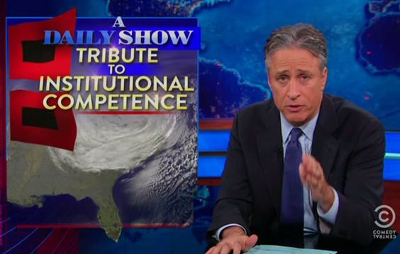
InstitutionalCompetence

A few days ago the Daily Show had a piece praising the effectiveness of preparations for and response to the storm.

The New York Times reports that the subways are operating again only a week after the disaster.

It has been less than two weeks since the most devastating storm in the New York City subway system’s 108-year history. Seven tunnels beneath the East River flooded. Entire platforms were submerged. Underground equipment, some of it decades old, was destroyed.

The damage was the worst that the system had ever seen. And yet, the subways have come back — quicker than almost anyone could have imagined. Less than three days after the storm hit, partial subway service was restored. Most major lines were back within a week. Repairs came so quickly in some cases that the authority was ready before Consolidated Edison had restored power.

“Some of what they’re doing borders on the edge of magic,” said Gene Russianoff, the staff lawyer for the Straphangers Campaign, a rider advocacy group that is frequently critical of the authority.

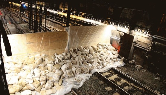
The forecasts lead to the protection of critical infrastructure and this is partly responsible for the rapid recovery compared to other disasters.

d1898_121028051328-04-sandy-1028-horizontal-gallery

Sealing up air vents in the subway

hurricane-sandy-streets-new-york_3

More protections of subways

lenox-storm-prep-jpg_980x551

hurricane-sandy-streets-new-york_9

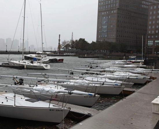
Battening boats

628x471

Removing underground electronics and pumps

Tuesday, November 6, 2012

Hurricane Sandy Photos and Recovery Stories

c7XMO

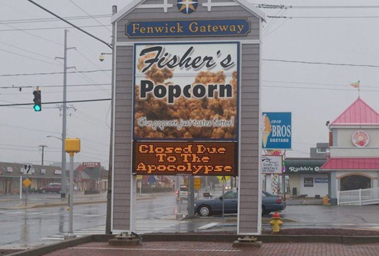
Closed due to the apocalypse.(Ocean City)

BreezyPoint

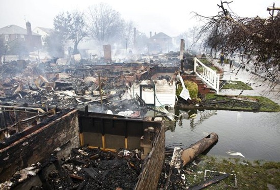
This aerial photo shows burned-out homes in the Breezy Point section of the Queens borough New York after a fire on Tuesday, Oct. 30, 2012. The tiny beachfront neighborhood told to evacuate before Sandy hit New York burned down as it was inundated by floodwaters, transforming a quaint corner of the Rockaways into smoke-filled debris.

eckert-1883_980x551

Photo: The day after Hurricane Sandy struck New York City sand and muck covers a car in Coney Island in Brooklyn, Tuesday, October 30, 2012. (Charles Eckert/Weather.com)

eckert-2396_980x551

Photo: A firefighter who lived in one of the approximately 100 houses destroyed by a fire that resulted from Hurricane Sandy, searches for his wifes wedding ring, in the Breezy Point section of Queens, Tuesday, October 30, 2012. (Charles Eckert/ Weather.com)

AP419204357677_980x551

Photo: Waves wash over a roller coaster from a Seaside Heights, N.J. amusement park that fell in the Atlantic Ocean during superstorm Sandy on Wednesday, Oct. 31, 2012. (AP Photo/Mike Groll)

hurricane-superstorm-sandy-hits-asbury-park_60716_600x450

Photo: Kim Johnson on Tuesday surveys the destruction around her flooded apartment in Atlantic City, New Jersey—one of several southern New Jersey coastal communities that bore the brunt of Hurricane Sandy's storm surge Monday night. Rivers of seawater gushed down city streets, swamped buildings, and destroyed a section of the city's iconic boardwalk.


hurricane-superstorm-sandy-hits-burned-homes-breezy-point_60720_600x450Photo: "We saw the glow and we couldn’t do a thing," deputy fire chief Lou Satriano told the Wall Street Journal's Metropolis blog. Satriano added that roads were also swamped and the burning homes themselves were standing in several feet of water—all of which gave the blaze time to spread. "It was a domino effect. Houses just caught and caught and caught fire."

enhanced-buzz-wide-31851-1352061559-9

A woman sifts through her mother's damaged home for items to save in Breezy Point, Queens.

enhanced-buzz-wide-21603-1352061933-14

Lost photos found.

enhanced-buzz-wide-32296-1352063521-17

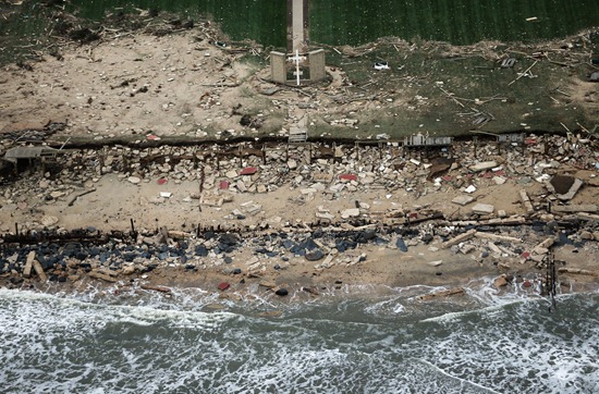
A church cross stands amid wreckage on the coast of Long Branch, New Jersey.

enhanced-buzz-wide-3696-1352064864-6

A dog named Shaggy is handed from a National Guard truck to National Guard personnel in Hoboken, New Jersey.

enhanced-buzz-wide-2307-1352066078-7

A photograph floats just below the surface of a flooded street in Massapequa, New York.

enhanced-buzz-wide-4148-1352066511-12

A Virgin Mary is all that remains from a home that was destroyed in Breezy Point, Queens.

nyc-hurricane-sandy-13

Flood protection examples: From sad

nyc-hurricane-sandy-18

to serious.

Sandbagexamples

Want to know the real way to defend yourself against floods? Read the Army Corps of Engineers flood fight handbook.

AP243539559034

Read about the massive pumps that are de-watering New York (at Wired and Wall Street Journal)

Finally, there’s a chronicle of someone’s experience during the days of the flood:

As New York sleeps, Sandy speeds up. Morning forecasts presage an ocean-going, full-scale, "life-threatening" weather demon. Lower Manhattan's pavements clear to let it pass. In certain parts, you can cross entire blocks without encountering more than a handful of people. In case you think you've misread that last sentence, that's whole blocks. …

About half an hour later, with the wind and the rain beating against the windows, the lights go out. Via phone message, word comes of an explosion down by 14th Street. A transformer has blown as floodwaters from the East River sweep into Manhattan….

After dark on Tuesday, there are two New Yorks: the one with power and the one without any power or mobile phone signal and, in parts, without water….

Uptown, the world suddenly comes back to life. It's as if nothing has ever happened. The storm debris has been cleared away; shops are open; restaurants are serving hot food.

Sunday, November 4, 2012

After the Storm (Hurricane Sandy)

Here’s a brief review of some news items about Hurricane Sandy…

The Daily Mail has four giant stories with lots of photos and videos. They will keep you reading for an hour. They cover

1. The misery of living without power

article-0-15D10729000005DC-735_634x418

Damage at Rockaway Beach

article-2227307-15D3F17F000005DC-460_634x405

Police provided cellphone charging stations. I’ve been at some airport power points that look like this.

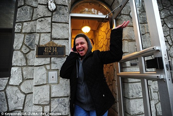
2. The ecstasy of having your power turned back on

article-2227092-15D33870000005DC-533_634x418article-2227092-15CEC55E000005DC-496_634x419

3. The next storm that’s approaching the area and the damage done to the shore

article-2226618-15CFA79D000005DC-750_634x453

4. The struggle to get gasoline

article-2227297-15D58132000005DC-382_634x423

There are frenzies over supplies of gasoline which at one point were declared free (10 gallons per customer, 11,000 gallons total). It was later clarified that emergency services/first responders (even off duty) would have first priority.

enhanced-buzz-15884-1351784009-0

Now there are long lines for transport into Manhattan

Some coverage of Atlantic City, picked from USA Today’s general page on Hurricane Sandy

John Paxton, a lifelong resident of Atlantic City, said: "This is the first time I have been down to see it. It is devastating, it looks like a bombed-out area. It is the first time I've seen mass destruction like this." Like many, the 75-year-old ignored evacuation warnings. He showed us how three feet of flood water had even left the food drawers in the bottom of his fridge filled with foul water. His home of 57 years is now caked in mud and sludge. He said: "When I saw the road outside had become a river, there was nothing else to do. I went to bed."

New York Times documents life in public housing after the storm.

Opened fire hydrants became community wells. Sleep-and-wake cycles were timed to sunsets and sunrises. People huddled for warmth around lighted gas stoves as if they were roaring fires. Darkness became menacing, a thing to be feared….

A few residents shrugged off the hardship, acknowledging that they had been told to evacuate and now were paying the price. “It’s just an inconvenience. Half the world does not have electricity,” said Ralph Lopez, 73… “I grew up in a cold-water flat with no heat at all. And this is just for a week. So boohoo.”"

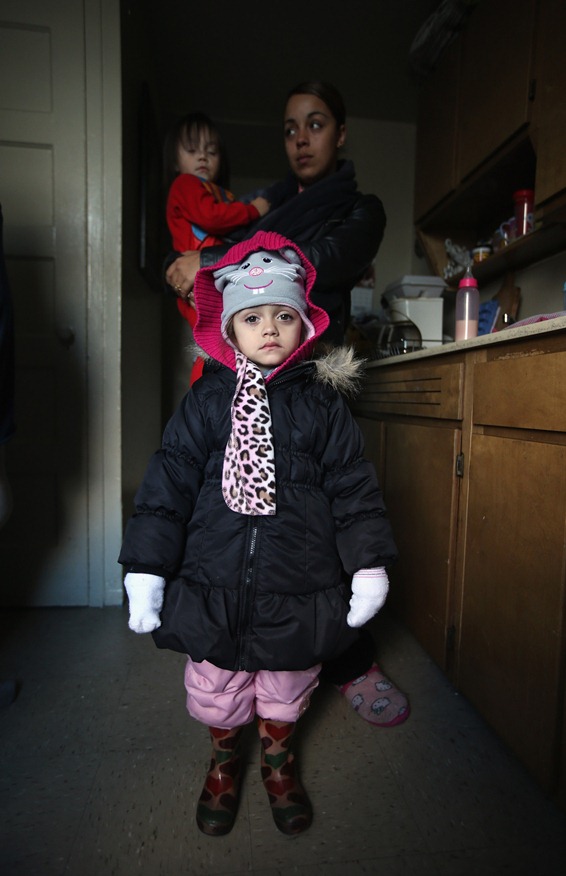
From a gallery of children after the storm at Buzzfeed

enhanced-buzz-wide-19606-1352044243-9

“Kate Traina, 14, looks over the rumble of her grandparents house in Staten Island, N.Y., Friday, Nov. 2, 2012.”

enhanced-buzz-wide-14235-1352044492-2

“At her family's 6th floor apartment in the Red Hook housing project on November 3, 2012 in the Brooklyn borough of New York City.”

Wednesday, October 31, 2012

Today Show Coverage of ECMWF Forecasts and other Sandy Links

Visit NBCNews.com for breaking news, world news, and news about the economy

Yesterday a film crew came and interviewed scientists from the European Center for Medium Range Weather Forecasts (ECMWF), the place where I am currently a visiting scientist. Above is the link and below is part of the transcript.

“Thousands of miles from the storm here in England, that group of scientists were making cutting-edge calculations last week providing an early warning of the damage Sandy would do. It was a storm warning that must have seemed incredible to some. And because it was so early helped millions of Americans prepare for the worst. One week ago today, last Wednesday, Al [Roker] relayed a dire forecast on “Today” scientists in Europe predicting Sandy would hit the east coast.

ECMWFSandy1

On the right is the prediction from the American model, on the left ECMWF. The European Center pretty much nailed it from incredibly far in advance. This prompted MIT scientist Kerry Emanuel to write a piece in the Wall Street Journal titled “Why America Has Fallen Behind the World in Storm Forecasting”

The early call came from the European Weather Center in England, 250 staff posting 150 million weather observations every day but have seen nothing like this: A hurricane making a left hook into the Northeast. [To meteorologist] When you first saw this, what was your reaction?

Alan Thorpe: “Obviously we were concerned. Even eight days ahead we could see the tropical cyclone developing. To assess the odds of Sandy hitting the east coast, their super computer had created 51 forecasts; all had one outcome. All took the storm north and then towards the eastern seaboard.”

ECMWFSandy2

This is the map room on the second floor of ECMWF. In the middle is Anna Ghelli, a world authority on forecast verification.

Reporter: By the weekend, the American and European models had converged. Without these forecasts the human cost might have been far worse. [To meteorologist] Essentially you and the other 250 scientists working here probably saved lives?

Meteorologist: I think it certainly motivates all the people who work here”

ECMWFSandy3

Alan Thorpe (left) and reporter (right) in front of “The Big Board”.

For more updates on the storm, easily the biggest coverage is over at the Daily Mail, lots of large photos and videos. There is a gallery of damage on Coney Island. Early estimates of damage are around $15 Billion, but some as high as $50 Billion- Hurricane Katrina was about $100 Billion.

e4f69d0797d67b1e1f0f6a706700a095

Caskets floating from a grave in Maryland

Tuesday, October 30, 2012

Gotham City Flickers Out (Hurricane Sandy)

a6agkzqcyaaxwgd_custom-bc9b49d5631175c52288b741d527445f8bcc3d67-s6

The skyline of Manhattan is dark.

"This will be one for the record books," said John Miksad, senior vice president for electric operations at ConEdison. "This will be the largest storm-related outage in our history."

APTOPIX Superstorm Sandy

The site of Ground Zero has been flooded with sea water.

On Tuesday, the New York Stock Exchange was to be closed again - the first time it's been closed for two consecutive days due to weather since 1888, when a blizzard struck the city.

A6augGqCMAARmA_

Twitter’s photo of a PATH station flooding through an elevator shaft.

NBC New York has some video of Queens ablaze that looks like a post apocalyptic scene in the Terminator movies. I’m sure when dawn breaks in New York City, the media is going to go completely apeshit.

An out-of-control six-alarm blaze is ravaging the Breezy Point neighborhood in Queens and has destroyed more than 50 homes, the FDNY tweeted early Tuesd. FDNY Queens dispatcher directing units to fires, telling them they'll PASS other fires en route! 

A6Z2mAFCMAEJ0m-

Atlantic City boardwalk in pieces.

More on twitter: BREAKING: The water level at the Battery in #NYC has reached 11.25 feet, surpassing the all-time record of 11.2 feet set in 1821.

8518750

Not exactly sure where that number came from, but here’s the tide level at the Battery, NY. The blue line is the normal tides, the green line is what was added because of the storm. The red line is the two added together. For the southern tip of Manhattan the storm surge and the high tide’s timing couldn’t have been better (or worse depending on your perspective).

enhanced-buzz-wide-2963-1351542228-4

A gallery of photos of the storm from space.

lenox-storm-prep-jpg_980x551

Sandbags and plywood at Lenox rail terminal

enhanced-buzz-wide-3310-1351544428-6

Some people went whole hog when preparing for the storm. In this photo I can see a baseball bat, disco ball, and a Samurai sword.

NPR has fewer updates but of bigger stories, whereas WNYC is doing fast updates (WNYC also has an interactive webpage to show current flooding – drawing on National Weather Service forecasts). The Daily News is a good source for rapid updates. The weather channel has a good photo feed.

The USGS has a tide mapper that is running a little slow but their regular page for river gages is doing alright (at the moment New Jersey is not reporting any data). Eventually I’d like to write a story about the emergency gauges that the USGS installed, but the press releases are here and here.

Google Crisis Response has a Sandy webpage.

Monday, October 29, 2012

A City Without People (Hurricane Sandy)

When I came in to work this morning, the “Big Board” at the European Centre for Medium-range Weather Forecasts had switched from its typical view of Europe to cover the US. It’s clear something major is happening.

Some of the models keep the track out to sea, but most all the other guidance has the storm doing a right hook to the coast. The storm has been described as “Meteorologically Mind-Boggling”.

storm_18

A good amount of storm surge will pile up on the coast to the north of the storm. The National Hurricane Center is a good source for storm surge info. StormSurge

The light blue along the New Jersey coast is where there’s a 50% of getting more than 6 feet of storm surge. Once the storm hits land, it is expected to remain for a few days, meaning storm force winds for 48+ hours. The NWS issued warnings including phrases such as “… if you don’t survive”. Additionally

“One of the meteorologists on staff even provided his contact information, urging those who think the storm is “overhyped” to call and yell at him on Friday if it ends up not being as bad as they think. But, he said, even as they yell at him, he’ll be happy they are safe.”

To see the mandatory evacuation zones of New York, go to this interactive webpage

Evacuate

And the public transit system is suspended. This has caused some eerie scenes in places like Grand Central Station. The rest of these pictures are from the Metropolitan Transit Authority photo stream

8133043029_402bbaea7b_c8133423439_84dd3fa3f1_c

Workers are protecting critical infrastructure, such as putting inflatable dams at the entrances to the railways:

8134049846_09aae16ce4_c 8134022017_d164131205_c

8134049328_7b02676d2f_c

They are also removing sensitive expensive equipment, such as motor switches for the railway.

8132340786_52d2968898_c

I have to think of how it feels to be the person issuing the forecasts that are setting all of this in motion. What did that person eat for breakfast this morning? The decision to dismantle hardware and evacuate it is a huge cost to protect. Inflatable dams at subway inlets cost money to buy and set up. That said, it would be dumb to have the inflatable dam and to have not used it at a time like this. 

I also wonder how they know their protection is going to hold? Who monitors the structure as the water comes up on it, to hold back any leaks? I imagine the workers could stand there and argue about “yeah, that’s not going to hold, water’s going to come in there”. How would you settle a disagreement like that if you’ve never had practice and don’t know how to test it? Clearly people have some bad ideas about what’s effective as flood defenses, such as this buzzfeed roundup from the last New York flood

enhanced-buzz-4620-1351262682-4

A roll of towels is used to block flood waters from entering a store.

Stay dry out there!